")

[dropcap type=”circle”]S[/dropcap]torm ‘Aileen’ is set to bring strong winds to Wirral overnight with possible disruption on rush hour traffic tomorrow morning.
The risk period for disruptive gusts looks set to be between 11pm tonight and 4am tomorrow (Wednesday) morning, possibly bringing 70 to 75mph winds on exposed sections of the coast and over higher ground.
A statement from Wirral Council said: “Unsecured structures may suffer from any strong gusts.
“The knock on effects of the winds, particularly any downed trees, may well run into tomorrow morning’s rush hour, something to bear in mind.
“Advice is to secure unsecured objects around your home and put your wheelie bin somewhere sheltered if possible.”
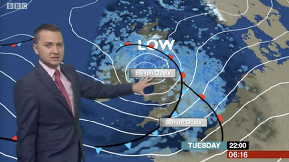
The Met Office has issued a yellow warning of strong winds and warned that along windward-facing coasts, some wave overtopping is possible.
There is also a chance of power cuts, and damage to trees and perhaps buildings. Along windward-facing coasts, some wave overtopping is possible.
Richard Leonard, road safety spokesperson at Highways England, said: “We’re encouraging drivers to check the latest weather and travel conditions before setting off on journeys, with strong winds expected from Tuesday evening until Wednesday morning. In high winds, there’s a particular risk to lorries, caravans and motorbikes so we’d advise drivers of these vehicles to slow down and avoid using exposed sections of road if possible.”
There has been some speculation that this weather is being driven by the severe weather in the Caribbean and US. There is no such connection. Met Office Deputy Meteorologist Chris Tubbs said: “There are no links between the very strong winds we expect to see here in the UK and the hurricanes affecting the United States and the Caribbean at present. This system originated well north in the Atlantic Ocean, independent of the current Caribbean hurricanes”.
As Storm Aileen clears out eastwards into the North Sea, the UK will be left with cool showery conditions through the end of the week and into the weekend. The showers will still be blustery on Thursday with the winds easing as we get closer to the weekend. Within the showers there will be some periods of brightness although it will still feel cool across the whole of the UK with top temperatures only reaching 18-19°C.
Wirral Council’s website also has useful advice on dealing with severe weather:
https://www.wirral.gov.uk/communities-and-neighbourhoods/emergencies/types-emergency/severe-weather